Arundel Castle and Arundel Park Walk
![]()
![]() This circular walk takes you through the parkland and countryside surrounding this restored medieval castle in West Sussex. The route includes lovely long waterside sections along the River Arun and a visit to a wildfowl reserve. It runs for about 8 miles on largely flat footpaths with a couple of moderate climbs on the way.
This circular walk takes you through the parkland and countryside surrounding this restored medieval castle in West Sussex. The route includes lovely long waterside sections along the River Arun and a visit to a wildfowl reserve. It runs for about 8 miles on largely flat footpaths with a couple of moderate climbs on the way.
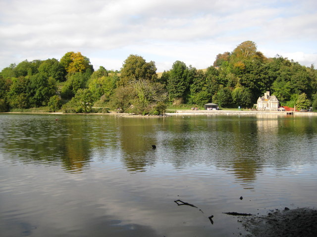
The walk starts near the castle and picks up the Monarch's Way long distance walking trail to take you into Arundel Park. This old deer park on the chalk of the South Downs has an ancient artificial lake, Swanbourne Lake. You'll pass the pretty lake and follow footpaths through woodland and grassland to the River Arun. The route then follows a lovely riverside footpath back towards the castle. You'll pass the splendid Arundel Wetland Centre where you can look out for a wide variety of wildlife including water voles and rare geese.
The castle itself is well worth visiting with lovely gardens, exquisite furniture, tapestries and a rare collection of paintings, though there is a fee for entry to the grounds. It also has a fascinating history dating back to 1067 and some of the original features such as the Norman Keep, medieval Gatehouse and Barbican survive today.
The Slindon Estate is located just a few miles to the west of the castle so you could continue your walking in the area by visiting this 1400 hectare estate.
If you follow the Monarch's Way east you will soon come to Angmering Park Estate Woods. There's miles of good cycling and walking trails to try here.
There's also the Amberley to Arundel Walk which takes you along a lovely waterside footpath next to the River Arun. Our Arundel Circular River Walk runs along both sides of the river and visits the interesting village of Burpham.
Postcode
BN18 9AB - Please note: Postcode may be approximate for some rural locationsArundel Castle and Arundel Park Ordnance Survey Map  - view and print off detailed OS map
Arundel Castle and Arundel Park Open Street Map  - view and print off detailed map
Arundel Castle and Arundel Park OS Map  - Mobile GPS OS Map with Location tracking
Arundel Castle and Arundel Park Open Street Map  - Mobile GPS Map with Location tracking
Explore the Area with Google Street View 
Pubs/Cafes
There's lots of good options for refreshments after you exercise. The St Mary’s Gate Inn has a fascinating history having been built in the 26th year of the reign of Henry VIII in 1525. The two other letting rooms which have been part of the building since the 16th century housed Oliver Cromwell and his guardsmen during the mid-1600. The pub has a great menu, good selection of ales and a cosy log fire. You can find it near the castle on London Rd at Postcode BN18 9BA.
The Red Lion on the High Street is another great option. This one dates back to the 18th century and includes a large beer garden to relax in. You can find it at postcode BN18 9AG.
Dog Walking
The expansive park with its parkland and woodland trails are ideal for dog walking. Dogs are not allowed inside the castle grounds though. The St Mary’s Gate Inn mentioned above is very welcoming to dogs.
Further Information and Other Local Ideas
The Arundel to Littlehampton River Walk will take you south along the Arun to the coast at Littlehampton. The neighbouring town is well worth a visit with its two award winning beaches, some fine architecture and the longest bench in Britain to see.
For more walking ideas in the area see the Sussex Walks and South Downs Walks pages.
Cycle Routes and Walking Routes Nearby
Photos
Swanbourne Lake was at one time a mill pond and has existed since pre-Domesday Book times. The building on the right is Swanbourne Lodge which was built in 1852. The lodge is in use as a restaurant and the hire centre for rowing boats. The Lodge's website, which tells us they have 25 flavours of ice cream and which, alas, currently contains a classic grocer's apostrophe


