Blue Man Walk
16.2 miles (26 km)
![]()
![]() This woodland walk takes you through Broxa Forest, Dalby Forest and Langdale Forest in the North York Moors National Park. The walk starts at Reasty Bank Top Car Park and follows forest roads, earth tracks and paths through the coniferous forests to Allerston. There are some steeps climbs but also some splendid views of the North York Moors countryside to enjoy.
This woodland walk takes you through Broxa Forest, Dalby Forest and Langdale Forest in the North York Moors National Park. The walk starts at Reasty Bank Top Car Park and follows forest roads, earth tracks and paths through the coniferous forests to Allerston. There are some steeps climbs but also some splendid views of the North York Moors countryside to enjoy.
Postcode
YO13 0LE - Please note: Postcode may be approximate for some rural locationsPlease click here for more information
Blue Man Walk Ordnance Survey Map  - view and print off detailed OS map
Blue Man Walk Open Street Map  - view and print off detailed map
Blue Man Walk OS Map  - Mobile GPS OS Map with Location tracking
Blue Man Walk Open Street Map  - Mobile GPS Map with Location tracking
Explore the Area with Google Street View 
Cycle Routes and Walking Routes Nearby
Photos

Forest road in Broxa Forest near Broad Head Farm

Thornton Dale, Dalby Forest

Forest Track, Langdale Forest
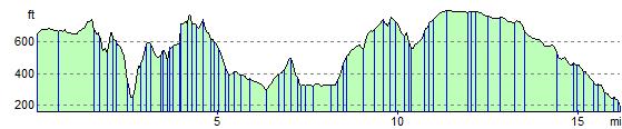
Elevation Profile
GPS Files
GPX File
Blue Man Walk.gpx (On Desktop:Right Click>Save As. On Ipad/Iphone:Click and hold>Download Linked File)NB GPS file for this route only details route start - route is waymarked from there in