Colne Valley Circular Walk
![]()
![]() Take in the stunning scenery of the Colne Valley on this circular footpath through Kirklees in Yorkshire.
Take in the stunning scenery of the Colne Valley on this circular footpath through Kirklees in Yorkshire.
The walk begins and ends at Golcar, passing Linthwaite, Slaithwaite and Marsden on the way. The path includes a waterside stroll along the Huddersfield Narrow Canal at the start, a stretch through Slaithwaite Moor and views of the picturesque Butterley Reservoir near Netherley. There are some challenging climbs on this walk but you are rewarded with fabulous views of the Colne Valley.
Colne Valley Circular Walk Ordnance Survey Map  - view and print off detailed OS map
Colne Valley Circular Walk Open Street Map  - view and print off detailed map
Colne Valley Circular Walk OS Map  - Mobile GPS OS Map with Location tracking
Colne Valley Circular Walk Open Street Map  - Mobile GPS Map with Location tracking
Pubs/Cafes
In Slaithwaite we recommend The Little Bridge which has a delightful outdoor terrace overlooking the canal. There's also a great menu and a cosy fire indoors on colder days. You can find the pub right next to the canal on Britannia Road with a postcode of HD7 5HF.
Cycle Routes and Walking Routes Nearby
Photos

Lock No 15E, Huddersfield Narrow Canal. According to one source, the bridge is called Scarwood Bridge; another has it as Appleyard Bridge. It carries a footpath which is part of the Colne Valley Circular Walk. The lock seems to be called Golcar Brook Lock, which makes sense, as the eponymous brook enters the canal here on the right hand side.

Memorial seat, Slaithwaite Moor, Slaithwaite. The path is the Colne Valley Circular Walk, seen from its junction with the Kirklees Way.

Plaque on memorial seat, Slathwaite Moor, Slaithwate This is at the junction of the Kirklees Way with the Colne Valley Circular Walk.

Entrance to Merrydale Clough, Slaithwaite. The public footpath sign reads 'Merrydale Clough'. The clough or valley was recently planted with a variety of native trees by White Rose Forest to form a wildlife corridor. Merrydale is a small secluded and peaceful part of the Colne Valley. There is now a waymarked circular walk along the clough.

Strange gate on the Colne Valley Circular Walk near Linthwaite.

Countryside around Slaithwaite

Path junction east of Marsden

Eastwards from Yew Tree
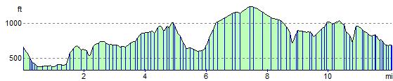
Elevation Profile