Great Gable Circular Walk
![]()
![]() Great Gable is one of the most popular mountains in the Lake District for climbers. It's a steep ascent with rugged paths, a fair amount of scrambling and some of the most spectacular rock scenery in the Lake District.
Great Gable is one of the most popular mountains in the Lake District for climbers. It's a steep ascent with rugged paths, a fair amount of scrambling and some of the most spectacular rock scenery in the Lake District.
This circular walk starts at the car park at Seathwaite and ascends to Stockley Bridge following Grains Gill along the way. You continue to Greenhow Knott where you will pass the beautiful Taylor Gill Force waterfall which drops an impressive 140 feet into the Seathwaite Valley. The next section takes you along Styhead Gill to the lovely Styhead Tarn turning north west to the summit of Great Gable.
The views from the peak are spectacular - you can see Ennerdale and Crummockdale, Pillar, Looking Stead, Haycock, Haystacks, High Crag, High Stile and Red Pike ridge.
The descent takes you through Great Gable's less famous (but still impressive) neighbour Green Gable, Mitchell Cove and Gillercomb. The final section runs along Sourmilk Gill to the finish point at Seathwaite car park.
Great Gable Ordnance Survey Map  - view and print off detailed OS map
Great Gable Open Street Map  - view and print off detailed map
*New* - Walks and Cycle Routes Near Me Map - Waymarked Routes and Mountain Bike Trails>>
Great Gable OS Map  - Mobile GPS OS Map with Location tracking
Great Gable Open Street Map  - Mobile GPS Map with Location tracking
Pubs/Cafes
The Glaramara House hotel in nearby Seatoller is in a stunning location. There's wonderful views of the Borrowdale Fells from the lovely outdoor seating area in the spacious grounds. It's the perfect place to relax after a long walk on a warm day. Indoors there's a cosy resident’s lounge with a log fire and a spacious bar. They do very good food and also provide top quality accommodation if you need to stay over. You can find the hotel just to the east of the National trust car park on the Honister Pass at postcode CA12 5XQ. From Seatoller you can also enjoy a climb to Thornythwaite Fell and Glaramara mountain.
Further Information and Other Local Ideas
At Seathwaite you can pick up the waymarked Allerdale Ramble. If you follow it north it will take you into beautiful Borrowdale.
For more walking ideas in the area see the Lake District Walks page.
Cycle Routes and Walking Routes Nearby
Photos

Beckhead Tarn from Great Gable. Great Gable is one of the most iconic peaks in the Lake District, located in the western part of the national park. It stands at 899 metres (2,949 feet) and is a prominent feature in the landscape, known for its striking shape and position. The mountain is part of the central Fells and is surrounded by other notable peaks, such as Scafell Pike, the highest mountain in England, and Kirk Fell.

Southern slopes of Great Gable. Great Gable offers some of the best views in the Lake District, with panoramic vistas extending across valleys, other mountain ranges, and distant coastlines on clear days. To the north, the stunning vista includes the expansive Wastwater, the deepest lake in England, while to the south, the views stretch over the valleys of Borrowdale and Derwentwater. From the summit, one can see far-reaching landscapes, including the Irish Sea on a good day, making it a prime location for hiking and photography.

Westmorland Cairn. Looking along Wasdale. Flora and fauna on Great Gable are typical of high-altitude mountain environments. The lower slopes are covered by a mix of heathland, grassland, and rocky outcrops, supporting a variety of wildflowers such as heather, bilberry, and sphagnum moss. Higher up, the landscape is dominated by rugged rocks and scree, with few plants able to survive in the harsh conditions. However, alpine plants like mountain avens and moss campion can be found in the crevices of the rocks, thriving in the harsh environment. The summit area is often a place of relative barren beauty, with few larger plants able to grow in the cold, windy conditions.

Plaque on the summit of Great Gable - Members of the Fell & Rock Climbing Club who died in the 1914 - 1918 war.

The summit of Great Gable, looking southwest, with Wast Water in the distance. The summit is marked by a large cairn, and its rocky outcrops and steep slopes make it a challenging but rewarding climb. The ascent is popular among hikers, with various routes leading to the top, including from Wasdale Head and Borrowdale. The mountain's ridges and crags, such as the well-known Westmorland Crags and Napes Needle, offer exciting climbing opportunities for experienced mountaineers. The mountain is also notable for its dramatic appearance when viewed from below, where the ridge seems to form a distinctive wedge shape, contributing to its reputation as one of the most photogenic mountains in the Lake District.

Towards the summit. Cairns mark the way on this tricky stretch on the path from Sty Head. The fauna of Great Gable is diverse, though the animals are typically adapted to the challenging conditions of the mountain. Red grouse can be spotted on the lower slopes, and various species of birds of prey, including peregrine falcons and kestrels, soar above the crags. In the early mornings, the haunting call of the curlew can sometimes be heard echoing across the valleys. Mammals such as red deer are also present in the area, although they are more commonly found in the surrounding valleys and forests. On the rocky crags, smaller creatures such as rock pipits and choughs can be seen, while the abundant insect life includes butterflies such as the mountain ringlet and common blue.
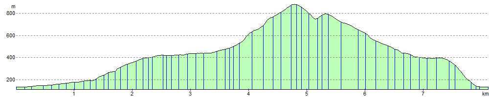
Elevation Profile