Latterbarrow Walk From Hawkshead with OS Map
![]()
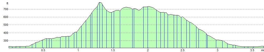
![]() This is a fairly easy climb to Latterbarrow Hill in the Lake District. The hill reaches a height of 803 feet (245 m) with splendid views over Esthwaite Water and Lake Windermere.
This is a fairly easy climb to Latterbarrow Hill in the Lake District. The hill reaches a height of 803 feet (245 m) with splendid views over Esthwaite Water and Lake Windermere.
This circular walk starts in Hawkshead, following country lanes and footpaths to the hill summit where you will find a stone monument. There's also splendid views of a number of fells including the Fairfield Horseshoe and Red Screes. The walk then descends through the woodland on Claife Heights, passing a number of tarns on the way.
If you'd like to continue your walking in the area then you could head to the nearby Wray Castle or explore the tarns and woodland of Claife Heights.
Latterbarrow Ordnance Survey Map  - view and print off detailed OS map
Latterbarrow Open Street Map  - view and print off detailed map
*New* - Walks and Cycle Routes Near Me Map - Waymarked Routes and Mountain Bike Trails>>
Latterbarrow OS Map  - Mobile GPS OS Map with Location tracking
Latterbarrow Open Street Map  - Mobile GPS Map with Location tracking
Pubs/Cafes
The 17th century Sun Inn in Hawkshead is a popular option for walkers. They do really good food including an excellent fish and chips. It's a friendly place and can be easily found in the village on Main Street with a postcode of LA22 0NT for your sat navs. The inn also provides good quality accommodation and is very dog friendly if you have your pet with you.
Cycle Routes and Walking Routes Nearby
Photos

Latterbarrow. View from Hawkshead. The hill is a local viewpoint for the village of Hawkshead. Accessible by foot after a short walk, the views from the top are excellent in almost 360 degrees. On a good day the Howgills can be seen.

Ancient Semi Natural Woodland on the hill in the autumn of 2004. The woodland on the side of Latterbarrow has been there since before 1860 when the first OS map was produced. It is ancient semi natural woodland and part of the Ennerdale Water Site of Special Scientific Interest. The woodland is important for a range of lichens and mosses as well as the native birch and oak. The picture shows a typical view of the site with a group of children in the distance collecting acorns for Wild Ennerdale

Harebell growing on a limestone outcrop at Latterbarrow Nature Reserve

Monument on top of Latterbarrow

Track leading off the Flanks of Latterbarrow

Descending off Latterbarrow

Footpath on Old Intake

Looking over Windermere on a cold day in February.
Elevation Profile