River Parret Trail
![]()
![]() Follow the River Parrett from the source in Chedington in Dorset to the mouth in Bridgwater Bay, Somerset.
Follow the River Parrett from the source in Chedington in Dorset to the mouth in Bridgwater Bay, Somerset.
The route first heads to Langport passing Haselbury and the 16th century English Heritage owned Muchelney Abbey. You continue north through Langport and onto Burrowbridge where you will pass the interesting geological and historical site at Burrow Mump. The river then takes you towards Bridgwater passing the Westonzoyland Pumping Station Museum. This Industrial Heritage museum is dedicated to steam powered machinery and makes for a fascinating few hours.
The final section takes you through Bridgwater and Combwich before finishing at the beautiful Steart Marshes Nature Reserve and Bridgwater Bay National Nature Reserve on Bridgwater Bay.
In Bridgwater the trail links with the Bridgwater and Taunton Canal which offers more great opportunities for waterside walking or cycling.
River Parret Trail Ordnance Survey Map  - view and print off detailed OS map
River Parret Trail Open Street Map  - view and print off detailed map
River Parret Trail OS Map  - Mobile GPS OS Map with Location tracking
River Parret Trail Open Street Map  - Mobile GPS Map with Location tracking
Pubs/Cafes
The King Alfred in Burrowbridge is a great place to stop for some refreshments on your walk. It's nestled under the shadow of Burrow Mump and the place where King Alfred famously burnt the cakes when he was hiding from the invading Danes, hence the pub’s name. It's a friendly place with great home cooked food. You can the find the pub next to the river at postcode TA7 0RB.
Further Information and Other Local Ideas
At Chedington the route links with the Brit Valley Way. This will take you along the River Brit to the coast at West Bay.
For more walking ideas in the area see the Dorset Walks and Somerset Walks pages.
Cycle Routes and Walking Routes Nearby
Photos
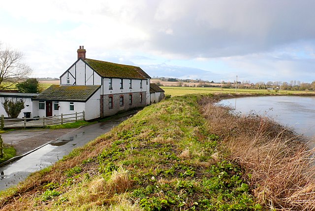
River Parret at Oath. The river has high embankments so that it can carry large volumes of water in spate with out flooding adjacent land. As can be seen the river is 4-5m above the level of the road and the ground floor of the house. The house is on the road from Oath to Stathe at the eastern end of West Sedgemoor. There is a pump house further along the road where water is pumped up from the moor into the river. When the river reaches the top of its banks, as it nearly is here, the moor is allowed to flood to protect property further downstream.
Combwich harbour. The village lies on Combwich Reach as the River Parrett flows to the sea and was the site of an ancient ferry crossing. It served as a port for the export of local produce and the import of timber from the 15th century. It also served the local brick and coal yard until the creek silted up in the 1930s. As of 2019, Combwich wharf is being used for the delivery of large equipment for the building of Hinkley Point C nuclear power station.


