Tame Valley Way
![]()
![]() Follow the River Tame through Greater Manchester from Stockport to Denshaw on this waterside walk. The trail passes through Ashton-under-Lyne, Stalybridge and Mossley and includes woodland sections as well as the extended sections along the River Tame and Huddersfield Narrow Canal. Also of interest is Reddish Vale Country Park, which sits right on the River Tame.
Follow the River Tame through Greater Manchester from Stockport to Denshaw on this waterside walk. The trail passes through Ashton-under-Lyne, Stalybridge and Mossley and includes woodland sections as well as the extended sections along the River Tame and Huddersfield Narrow Canal. Also of interest is Reddish Vale Country Park, which sits right on the River Tame.
Tame Valley Way Ordnance Survey Map  - view and print off detailed OS map
Tame Valley Way Open Street Map  - view and print off detailed map
Tame Valley Way OS Map  - Mobile GPS OS Map with Location tracking
Tame Valley Way Open Street Map  - Mobile GPS Map with Location tracking
Pubs/Cafes
On the route we recommend stopping for refreshments at the Roaches Lock Inn in Mossley. The pub's main attraction is a lovely beer garden with fine views of the Huddersfield Narrow Canal. It's an ideal spot for a rest on a fine day. You can find it at 387 Manchester Road with postcode OL5 9BB for your sat nav.
Further Information and Other Local Ideas
For more walking ideas in the area see the Greater Manchester Walks page.
Cycle Routes and Walking Routes Nearby
Photos

Tame Valley Way. The entrance to the footpath and bridleway, from Mill Lane. It leads along the bank of the river Tame and behind the old "Kingston Stink"

Dukinfield. Entrance to Cooper's Ride section of the Tame Valley Way.

Countryside view near Stalybridge

River Tame going under the Reddish - New Mills, Buxton Railway Viaduct

Saddleworth

Old Railway arch near Greenfield
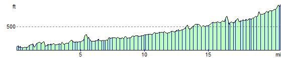
Elevation Profile