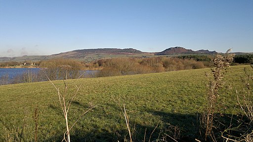
Tittesworth Reservoir Walk

 Enjoy a circular walk around this lovely reservoir on the edge of the Peak District. There are waterside sections along the shoreline, woodland trails and fantastic views of the nearby Hen Cloud and The Roaches. The walk starts and ends at the visitor centre at the northern end of Tittesworth Water. Here you will find a cafe, an interactive exhibition, and picnic areas overlooking the River Churnet Valley.
If you'd like to continue your walking you could climb to The Roaches for one of the best ridge walks in the country.
A few miles to the east you'll find Rudyard Lake which has great waterside walking and cycling trails.
Postcode
ST13 8SW - Please note: Postcode may be approximate for some rural locationsTittesworth Reservoir Ordnance Survey Map  - view and print off detailed OS map
Tittesworth Reservoir Open Street Map  - view and print off detailed map
Tittesworth Reservoir OS Map  - Mobile GPS OS Map with Location tracking
Tittesworth Reservoir Open Street Map  - Mobile GPS Map with Location tracking
Pubs/Cafes
The Lazy Trout is a popular place to go for walkers after they're exercise. It's full of character and has a nice big garden area to sit out in on warmer days. You can find it at the northern end of the reservoir at postcode ST13 8SN for your sat navs.
You could also head south into the market town of Leek where there's a number of good options including the excellent Haregate Fish Bar on Queens Drive and the noteworthy Abbey Inn. The historic inn dates all the way back to the 18th century and has a good menu. The front of the building has a south facing patio great for dining and a relaxing drink on warmer days. There's also a boules court if you fancy a game. You can find the pub on Abbey Green Road at a postcode of ST13 8SA.
To the east there's the village of Blackshaw Moor and The Three Horseshoes. The high quality inn includes beautiful gardens, a patio, and stunning views over the Roaches and surrounding countryside. The pub was named by CAMRA in 2019 as having one of the top ten beer gardens in the UK. The interior is charming too with oak beams and open fires for colder days. You can find them on the Buxton Road at postcode ST13 8TW for your sat navs.
Dog Walking
The reservoir and the surrounding woods are a great place for a dog walk so you'll probably see plenty of other owners on your outing. The Lazy Trout and Abbey Inn pubs mentioned above are also very dog friendly.
Further Information and Other Local Ideas
One nice idea is to head about a mile south of the water and enjoy a stroll around Leek. Here you'll find the pretty Brough Park. The Victorian park has nice footpaths taking you to gardens, wide lawns and a pretty pond. You can find the park at a postcode of ST13 6AT.


