Weighver's Way
![]()
![]() This is a terrific, challenging walk from Littleborough to Catley Lane Head, Rochdale.
This is a terrific, challenging walk from Littleborough to Catley Lane Head, Rochdale.
The path begins at the lovely Hollingworth Lake and heads through Littleborough along the Rochdale Canal. The next section climbs to the beautiful Watergrove Reservoir which is a lovely place to stop for a picnic. You then pass Whitworth on your way to the splendid Healey Dell Nature Reserve.
This attractive reserve sits in the Spodden Valley and right on the route. It is a real trail highlight with water mills, wildlife, picnic areas and the 1867 Healey Dell Viaduct. Shortly after the route finishes at Catley Lane Head.
Weighver's Way Ordnance Survey Map  - view and print off detailed OS map
Weighver's Way Open Street Map  - view and print off detailed map
Weighver's Way OS Map  - Mobile GPS OS Map with Location tracking
Weighver's Way Open Street Map  - Mobile GPS Map with Location tracking
Pubs/Cafes
Right next to Hollingworth Lake is the splendid Wine Press. This contemporary British Restaurant includes a lovely outdoor seating area where you can enjoy fine views over the lake with your lunch. There's also an attractive modern interior for cooler days. The pub is also dog friendly.
Cycle Routes and Walking Routes Nearby
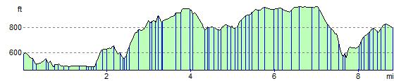
Elevation Profile