Andover to Newbury
![]()
![]() Follow National Cycle routes 246 and 4 from Hampshire into Berkshire on this attractive route.
Follow National Cycle routes 246 and 4 from Hampshire into Berkshire on this attractive route.
You start off at Andover railway station and head north along country lanes through Hurstbourne Tarrant, Faccombe and Kintbury where you join the Kennet and Avon Canal for the final pleasant waterside stretch to Newbury.
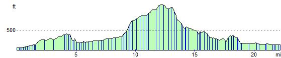
There's some beautiful countryside to enjoy as well as a peaceful section through Faccombe wood and a short run through Inkpen common. On the way you'll pass the highest point in Berkshire at Walbury Hill.
The route is easily accessible with train stations at either end.
Andover to Newbury Ordnance Survey Map  - view and print off detailed OS map
Andover to Newbury Open Street Map  - view and print off detailed map
Andover to Newbury OS Map  - Mobile GPS OS Map with Location tracking
Andover to Newbury Open Street Map  - Mobile GPS Map with Location tracking
Pubs/Cafes
In Newbury you will find the delightful Tea Shop By The Canal which is perfect for afternoon tea. Set in an interesting old Grade II listed building the tea shop blends the comfort and warmth of Italian culture with the fine and splendid rituals of English Cream Teas. There's also outdoor seating so you can sit out right next to the canal on warm summer days. You can find it at The Stone Building, The Wharf, Newbury with a postcode of RG145AS.
In the pretty village of St Mary Bourne there's the George Inn. The pub does a fine Sunday Carvery and is popular with cyclists and walkers. Postcode for sat navs is SP11 6BG.
Cycle Routes and Walking Routes Nearby
Elevation Profile