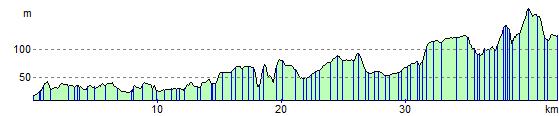
Bath to Longleat Safari Park
28 miles (45 km)
![]()
![]() Follow National Cycle Route 4 and the Wiltshire Cycleway through Somerset and Wiltshire to this popular tourist attraction.
Follow National Cycle Route 4 and the Wiltshire Cycleway through Somerset and Wiltshire to this popular tourist attraction.
The route starts on Pulteney Bridge in Bath and follows National Cycle route 4 and the River Avon to Bradford-On-Avon. You'll then turn south east along the Wiltshire Cycleway to Westbury on minor roads before finishing on the cycle paths through Longleat Park finishing at Longleat House. Here you could visit the popular Heaven's Gate where there are some lovely trees and gardens to see.
Bath to Longleat Safari Park Ordnance Survey Map  - view and print off detailed OS map
Bath to Longleat Safari Park Open Street Map  - view and print off detailed map
Bath to Longleat Safari Park OS Map  - Mobile GPS OS Map with Location tracking
Bath to Longleat Safari Park Open Street Map  - Mobile GPS Map with Location tracking
Cycle Routes and Walking Routes Nearby
Elevation Profile