Bellingham to Langholm
![]()
![]() This ride follows National Cycle Route 10 and the Reivers Route through the beautiful and tranquil Northumberland National Park, and over the border into Scotland. You start at Bellingham (known as the gateway to Kielder Forest) with an on road section which takes you along the River North Tyne, around Kielder Water and into the lovely Kielder Forest.
This ride follows National Cycle Route 10 and the Reivers Route through the beautiful and tranquil Northumberland National Park, and over the border into Scotland. You start at Bellingham (known as the gateway to Kielder Forest) with an on road section which takes you along the River North Tyne, around Kielder Water and into the lovely Kielder Forest.
The stretch around Kielder Water is spectacular and another lovely waterside run soon follows along the Lewis Burn. The ride then continues through the forest on cycle paths to Newcastleton in Scotland. Quiet roads then take you onto the finish point in Langholm on the River Esk.
Bellingham to Langholm Ordnance Survey Map  - view and print off detailed OS map
Bellingham to Langholm Open Street Map  - view and print off detailed map
Bellingham to Langholm OS Map  - Mobile GPS OS Map with Location tracking
Bellingham to Langholm Open Street Map  - Mobile GPS Map with Location tracking
Pubs/Cafes
The Kielder Castle Café is a nice place to enjoy some refreshments on the ride. It is integrated in the ancient Kielder castle which was built in 1775 as a hunting lodge for the Duke of Northumberland. The cosy family run Café serves locally sourced homemade food daily including, breakfasts, lunches, snacks, soups and cakes. The building also includes a free exhibition, an open log fire, a wildlife camera and an area where you can view the native red squirrels on the feeder outside.
Cycle Routes and Walking Routes Nearby
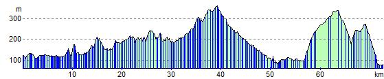
Elevation Profile