Bristol to Thornbury
24.9 miles (40 km)
![]()
![]() This route starts by the River Avon in Bristol and follows the tow path for a few miles before heading north along National Cycle Route 4 to Thornbury.
This route starts by the River Avon in Bristol and follows the tow path for a few miles before heading north along National Cycle Route 4 to Thornbury.
See the Bristol Cycle Routes page for more cycling ideas in and around the city.
Bristol to Thornbury Ordnance Survey Map  - view and print off detailed OS map
Bristol to Thornbury Open Street Map  - view and print off detailed map
Bristol to Thornbury OS Map  - Mobile GPS OS Map with Location tracking
Bristol to Thornbury Open Street Map  - Mobile GPS Map with Location tracking
Cycle Routes and Walking Routes Nearby
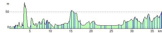
Elevation Profile