Burnley to Hebden Bridge
![]()
![]() This hilly ride follows National Cycle route 68 from Lancashire into Yorkshire. You start on the Leeds and Liverpool Canal in Burnley and follow the towpath to the edge of town before passing Towneley Park and Towneley Hall which is well worth a look. The route continues on road through Stiperden and Stansfield Moor before a short stretch along the Rochdale Canal takes you to the finish point by Hebden Bridge Railway station.
This hilly ride follows National Cycle route 68 from Lancashire into Yorkshire. You start on the Leeds and Liverpool Canal in Burnley and follow the towpath to the edge of town before passing Towneley Park and Towneley Hall which is well worth a look. The route continues on road through Stiperden and Stansfield Moor before a short stretch along the Rochdale Canal takes you to the finish point by Hebden Bridge Railway station.
On the way look out for the views of the Stoodley Pike monument, one of the landmarks of the area.
Burnley to Hebden Bridge Ordnance Survey Map  - view and print off detailed OS map
Burnley to Hebden Bridge Open Street Map  - view and print off detailed map
Burnley to Hebden Bridge OS Map  - Mobile GPS OS Map with Location tracking
Burnley to Hebden Bridge Open Street Map  - Mobile GPS Map with Location tracking
Pubs/Cafes
In Hebden Bridge there's the excellent Rim Nam Thai Restaurant. It's located in a wonderful spot right on the canal side just a short distance from The Hebden Bridge Picture House. It's a great place to enjoy a fine meal with a lovely scenic view. You can find it at Butlers Wharf at postcode HX7 8AF. A little to the west of the town centre there's also the noteworthy Fox & Goose Inn. The pub is the first community-owned pub in West Yorkshire. The friendly place is well worth some investigation with its cosy interior with a roaring fire and an exhibition space for local artists to display their work. Outside there's a lovely hillside beer garden which is great on warmer days. The place is also very dog friendly and will provide water bowls and free biscuits. You can find the pub at 7 Heptonstall Road with a postcode of HX7 6AZ for your sat navs.
Further Information and Other Local Ideas
The route passes along part of the epic Pennine Cycleway which can be used to further extend your ride.
Cycle Routes and Walking Routes Nearby
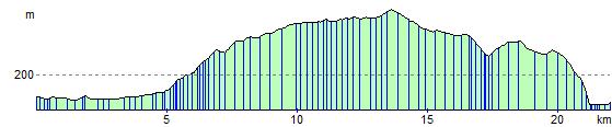
Elevation Profile