Burnley to Settle
32.3 miles (52 km)
![]()
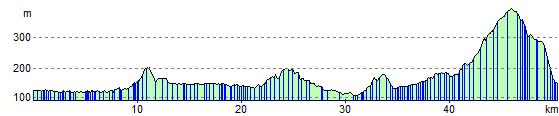
![]() Follow National Cycle route 68 through Lancashire and the Yorkshire Dales. You start on the Leeds and Liverpool Canal in Burnley and follow the towpath to Colne. A short stretch around Fouldridge Reservoir takes you back onto the canal to Gargrave. Here you head into the Yorkshire Dales National Park on a mixture of country roads and off road tracks passing the beautiful Scaleber Force waterfall before arriving in the market town of Settle.
Follow National Cycle route 68 through Lancashire and the Yorkshire Dales. You start on the Leeds and Liverpool Canal in Burnley and follow the towpath to Colne. A short stretch around Fouldridge Reservoir takes you back onto the canal to Gargrave. Here you head into the Yorkshire Dales National Park on a mixture of country roads and off road tracks passing the beautiful Scaleber Force waterfall before arriving in the market town of Settle.
Burnley to Settle Ordnance Survey Map  - view and print off detailed OS map
Burnley to Settle Open Street Map  - view and print off detailed map
Burnley to Settle OS Map  - Mobile GPS OS Map with Location tracking
Burnley to Settle Open Street Map  - Mobile GPS Map with Location tracking
Further Information and Other Local Ideas
The route passes along part of the epic Pennine Cycleway which can be used to further extend your ride.
Cycle Routes and Walking Routes Nearby
Elevation Profile