Burton-Upon-Trent to Uttoxeter
24.9 miles (40 km)
![]()
![]() Travel through Staffordshire and Derbyshire along National Cycle Route 54 on this interesting route. You start near the railway station in Burton Upon Trent and head north to Egginton in Derbyshire, with views of the River Trent and the Trent & Mersey Canal. The route continues through the countryside mainly on road but with a short stretch along a dismantled railway line near Etwal and Hilton. Other villages of note on the route are Hatton, Marston on Dove and Sudbury - home to National Trust owned Sudbury Hall with its interesting history and attractive gardens.
Travel through Staffordshire and Derbyshire along National Cycle Route 54 on this interesting route. You start near the railway station in Burton Upon Trent and head north to Egginton in Derbyshire, with views of the River Trent and the Trent & Mersey Canal. The route continues through the countryside mainly on road but with a short stretch along a dismantled railway line near Etwal and Hilton. Other villages of note on the route are Hatton, Marston on Dove and Sudbury - home to National Trust owned Sudbury Hall with its interesting history and attractive gardens.
Shortly after leaving Sudbury you will cross the River Dove near Doveridge and arrive at the finish point at Uttoxeter railway station.
Burton-Upon-Trent to Uttoxeter Ordnance Survey Map  - view and print off detailed OS map
Burton-Upon-Trent to Uttoxeter Open Street Map  - view and print off detailed map
Burton-Upon-Trent to Uttoxeter OS Map  - Mobile GPS OS Map with Location tracking
Burton-Upon-Trent to Uttoxeter Open Street Map  - Mobile GPS Map with Location tracking
Cycle Routes and Walking Routes Nearby
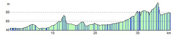
Elevation Profile