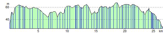
Bury St Edmunds to Stowmarket
18.6 miles (30 km)
![]()
![]() Follow National Cycle Route 51 from Bury St Edmunds to Stowmarket. The route starts near the ruined abbey near the town centre and then meanders through the suffolk countryside along country roads. There are also several off road sections and few climbs making for an easy afternoon's cycling. The route finishes at the train station in Stowmarket.
Follow National Cycle Route 51 from Bury St Edmunds to Stowmarket. The route starts near the ruined abbey near the town centre and then meanders through the suffolk countryside along country roads. There are also several off road sections and few climbs making for an easy afternoon's cycling. The route finishes at the train station in Stowmarket.
Bury St Edmunds to Stowmarket Ordnance Survey Map  - view and print off detailed OS map
Bury St Edmunds to Stowmarket Open Street Map  - view and print off detailed map
Bury St Edmunds to Stowmarket OS Map  - Mobile GPS OS Map with Location tracking
Bury St Edmunds to Stowmarket Open Street Map  - Mobile GPS Map with Location tracking
Cycle Routes and Walking Routes Nearby
Elevation Profile