National Cycle Route 51
![]()
![]() This is the complete Sustrans National Cycle Route 51 running from Oxford to Colchester. It runs for over 200 miles passing several significant towns and cities in the south of England.
This is the complete Sustrans National Cycle Route 51 running from Oxford to Colchester. It runs for over 200 miles passing several significant towns and cities in the south of England.
You can download the full gpx for the route at the bottom of the page. Scroll down for maps, videos, photos and cycle routes that run along trail.
Starting in the famous university town of Oxford the route heads to Kidlington, Bicester, Milton Keynes and Bedford. Near here you'll pass the pretty Furzton Lake and Willen Lake where there are good wildlife spotting opportunities. There's also the traffic free Bedford to Sandy Way, a pleasant section suitable for walkers and cyclists.
You continue to St Neots and the splendid Grafham Water where there's an excellent circular cycle ride around the water.
The next stage passes through Huntingdon to another university city at Cambridge. Here part of the route runs along the popular Cambridge to St Ives along the Busway, a traffic free section along the splendid busway between the two settlements.
The route continues east to the racecourse town of Newmarket, Bury St Edmunds, Stowmarket and Ipswich where there's views of the Gipping Valley River.
You then head to the Suffolk coast at Felixstowe before continuing through Harwich and finishing at the Roman town of Colchester.
Cycle Routes on National Cycle Route 51
- Oxford to Milton Keynes - Starting in the historic University town of Oxford follow NCN route 51 from Oxford to Milton Keynes via Bicester
- Milton Keynes to Bedford - Follow the trail from Buckinghamshire into Bedfordshire on this pleasant route
- Grafham Water Circular Ride - A cycle and walking route around the beautiful Grafham Water in Cambridgeshire.
The route passes through woodland and the villages of Grafton and West Perry - Huntingdon to St Neots - This ride follows the trail through Cambridgeshire
- Cambridge to St Ives along the Busway - Enjoy a walk or cycle along this disused railway line which now forms part of National Cycle Network Route 51
- Cambridge to Huntingdon - This route follows National Cycle routes 11 and 51 through Cambridgeshire from Cambridge to Huntingdon
- Cambridge to Ely - This route follows National Cycle routes 11 and 51 through Cambridgeshire
- Cambridge to Newmarket - This route follows National Cycle routes 11 and 51 through Cambridgeshire to Suffolk
- Newmarket to Bury St Edmunds - This route follows the trail through the Suffolk countryside
- Bury St Edmunds to Stowmarket - Follow the trail from Bury St Edmunds to Stowmarket
- Felixstowe to Ipswich - Follow the trail from the Suffolk coast to the county town
- Colchester to Harwich - This route follows the trail to the Essex coast
National Cycle Route 51 Ordnance Survey Map  - view and print off detailed OS map
National Cycle Route 51 Open Street Map  - view and print off detailed map
*New* - Walks and Cycle Routes Near Me Map - Waymarked Routes and Mountain Bike Trails>>
National Cycle Route 51 OS Map  - Mobile GPS OS Map with Location tracking
National Cycle Route 51 Open Street Map  - Mobile GPS Map with Location tracking
Further Information and Other Local Ideas
The Varsity Way Oxford to Cambridge Cycle Route uses part of the route as it makes its way between the two famous university cities.
Photos
This is a traffic free section of route 51 of the National Cycle network, seen here crossing the entrance to the Flying Fortress pub near Bury St Edmunds.
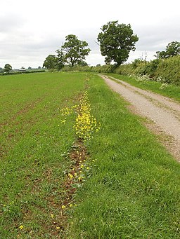
Abovemead Farm across wheat field, near Winslow. View from the bridleway.
The bridleway is a traffic-free part of the route east of Winslow. The field has a wheat crop, not well advanced so probably sown in the spring.


