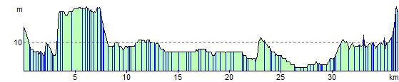
Cambridge to Huntingdon
23.6 miles (38 km)
![]()
![]() This route follows National Cycle routes 11 and 51 through Cambridgeshire from Cambridge to Huntingdon.
This route follows National Cycle routes 11 and 51 through Cambridgeshire from Cambridge to Huntingdon.
The route starts with a pleasant off road stretch along the River Cam passing by some of the city's famous University Colleges. The route then follows the Great River Ouse passing through St Ives and Godmanchester before finishing near the train station in Huntingdon.
Cambridge to Huntingdon Ordnance Survey Map  - view and print off detailed OS map
Cambridge to Huntingdon Open Street Map  - view and print off detailed map
Cambridge to Huntingdon OS Map  - Mobile GPS OS Map with Location tracking
Cambridge to Huntingdon Open Street Map  - Mobile GPS Map with Location tracking
Cycle Routes and Walking Routes Nearby
Elevation Profile