Chester to Runcorn
![]()
![]() This ride follows National Cycle Route 5 through Cheshire which passes the impressive Chester Zoo.
This ride follows National Cycle Route 5 through Cheshire which passes the impressive Chester Zoo.
The route starts by the railway station in Chester and soon joins the Shropshire Union Canal for some pleasant waterside riding. You then pass through the outskirts of Chester on road before coming to the zoo which is well worth a visit. Soon after you rejoin the canal which takes you onto Little Stanley.
The route then turns east towards Elton and Ince where you join a traffic free section running parallel to the Manchester Ship Canal. This takes you into Frodsham where you cross the River Weaver. Minor roads take you through Aston before a long pleasant traffic free section takes you into Runcorn finishing by the tourist information centre.
Chester to Runcorn Ordnance Survey Map  - view and print off detailed OS map
Chester to Runcorn Open Street Map  - view and print off detailed map
Chester to Runcorn OS Map  - Mobile GPS OS Map with Location tracking
Chester to Runcorn Open Street Map  - Mobile GPS Map with Location tracking
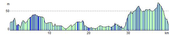
Cycle Routes and Walking Routes Nearby
Elevation Profile