Cirencester to Stroud
22 miles (35 km)

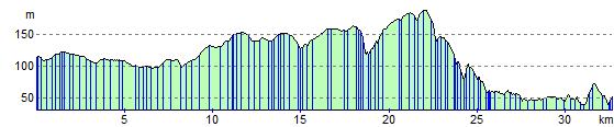
 Follow National Cycle routes National Cycle Route 48 and 45 through the beautiful Cotswolds region on this attractive route which takes you close to the source of the River Thames. The route starts near the abbey grounds in Cirencester and follows National Cycle Route 48 to Kemble where you will join National Cycle Route 45. The route continues on the Thames path and minor roads through the Cotswolds to Nailsworth where an off road path takes you into Stroud finishing near the River Frome.
Cirencester to Stroud Ordnance Survey Map  - view and print off detailed OS map
Cirencester to Stroud Open Street Map  - view and print off detailed map
Cirencester to Stroud OS Map  - Mobile GPS OS Map with Location tracking
Cirencester to Stroud Open Street Map  - Mobile GPS Map with Location tracking
Elevation Profile