Coventry to Leicester
![]()
![]() Follow National Cycle Route 52 and National Cycle Route 63 through the West Midlands, Warwickshire and into Leicestershire. The route starts on the Coventry Canal on the outskirts of Coventry and heads north along the canal and National Cycle route 52 to Bedworth. A short on road section then takes you through Bedworth before rejoining the tow path of the canal which takes you into Nuneaton in Warwickshire. A short stretch along the lovely off road Weddington Country Walk follows before an on road section by the Ashby-de-la-Zouch canal takes you onto Market Bosworth. You then turn east along National Cycle route 63 just after Shackerstone. A pleasant off road section then follows through Grange Wood before country roads take you onto Thornton, passing Bagworth Heath Woods and Thornton Reservoir.
Follow National Cycle Route 52 and National Cycle Route 63 through the West Midlands, Warwickshire and into Leicestershire. The route starts on the Coventry Canal on the outskirts of Coventry and heads north along the canal and National Cycle route 52 to Bedworth. A short on road section then takes you through Bedworth before rejoining the tow path of the canal which takes you into Nuneaton in Warwickshire. A short stretch along the lovely off road Weddington Country Walk follows before an on road section by the Ashby-de-la-Zouch canal takes you onto Market Bosworth. You then turn east along National Cycle route 63 just after Shackerstone. A pleasant off road section then follows through Grange Wood before country roads take you onto Thornton, passing Bagworth Heath Woods and Thornton Reservoir.
A mixture of off road paths and quiet roads takes you onto the finish point in Leicester on the Grand Union Canal.
Coventry to Leicester Ordnance Survey Map  - view and print off detailed OS map
Coventry to Leicester Open Street Map  - view and print off detailed map
Coventry to Leicester OS Map  - Mobile GPS OS Map with Location tracking
Coventry to Leicester Open Street Map  - Mobile GPS Map with Location tracking
Cycle Routes and Walking Routes Nearby
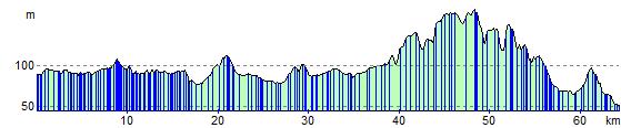
Elevation Profile