Crinan to Taynuilt
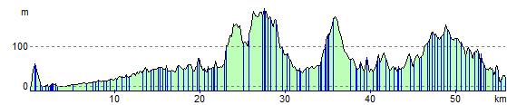
36 miles (58 km)
![]()
![]() This stunning ride follows the Caledonia Way (National Cycle route 78) through Kilmartin Glen and includes a wonderful long stretch along Loch Awe.
This stunning ride follows the Caledonia Way (National Cycle route 78) through Kilmartin Glen and includes a wonderful long stretch along Loch Awe.
The ride starts overlooking Loch Crinan before joining the Crinan Canal to Bellanoch. You then turn north towards Kilmartin with the fascinating Temple Wood stone circle a highlight on this section. The ride then heads towards Ford passing Loch Ederline before heading into Inverliever Forest where you will pass along the beautiful Loch Awe to Kilchrenan. You then turn north towards Taynuilt passing through the Caledonian Forest Reserve before finishing near Taynuilt train station.
Crinan to Taynuilt Ordnance Survey Map  - view and print off detailed OS map
Crinan to Taynuilt Open Street Map  - view and print off detailed map
Crinan to Taynuilt OS Map  - Mobile GPS OS Map with Location tracking
Crinan to Taynuilt Open Street Map  - Mobile GPS Map with Location tracking
Cycle Routes and Walking Routes Nearby
Elevation Profile