Derby to Ashbourne
21.7 miles (35 km)
![]()
![]() Follow National Cycle Route 54 through Derbyshire on this lovely route. The route starts by the tourist information centre in Derby and heads west to Mickleover where you join a dismantled railway line taking you to Etwal. The route continues through the countryside on quiet roads, through the villages of Longford and Rodsley, before finishing by the tourist information centre in Ashbourne.
Follow National Cycle Route 54 through Derbyshire on this lovely route. The route starts by the tourist information centre in Derby and heads west to Mickleover where you join a dismantled railway line taking you to Etwal. The route continues through the countryside on quiet roads, through the villages of Longford and Rodsley, before finishing by the tourist information centre in Ashbourne.
Derby to Ashbourne Ordnance Survey Map  - view and print off detailed OS map
Derby to Ashbourne Open Street Map  - view and print off detailed map
Derby to Ashbourne OS Map  - Mobile GPS OS Map with Location tracking
Derby to Ashbourne Open Street Map  - Mobile GPS Map with Location tracking
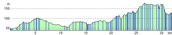
Elevation Profile