Dover to Canterbury
![]()
![]() Starting in Dover follow National Cycle route 1 along the coast through Kingsdown to Deal where there a views of Deal Castle. You then had inland through Sandwich (home of open golf) passing the River Stour and heading west to Canterbury via Westbere Lakes.
Starting in Dover follow National Cycle route 1 along the coast through Kingsdown to Deal where there a views of Deal Castle. You then had inland through Sandwich (home of open golf) passing the River Stour and heading west to Canterbury via Westbere Lakes.
You finish in Canterbury with its splendid cathedral and grounds.
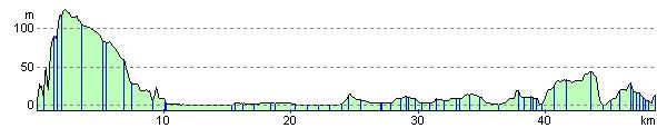
The route is largely flat with only a couple of ascents making it quite a leisurely ride.
Dover to Canterbury Ordnance Survey Map  - view and print off detailed OS map
Dover to Canterbury Open Street Map  - view and print off detailed map
Dover to Canterbury OS Map  - Mobile GPS OS Map with Location tracking
Dover to Canterbury Open Street Map  - Mobile GPS Map with Location tracking
Further Information and Other Local Ideas
Just east of Canterbury you can visit the Stodmarsh National Nature Reserve which boasts the largest reedbeeds in the South East of England. This area also includes the lovely Grove Ferry Walk which starts at the eastern end of the reserve. There's a car park, picnic area, boat trips and a fine riverside pub here. At the western end of the reserve you'll also find the Westbere Marshes and the noteworthy town of Fordwich. Fordwich is notable as Britain's smallest town and also has a great pub with a dining terrace overlooking the Stour.
Cycle Routes and Walking Routes Nearby
Elevation Profile