Dumfries to Castle Douglas
![]()
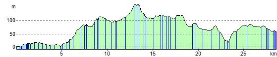
![]() This ride follows National Cycle Route 7 from Dumfries to Castle Douglas.
This ride follows National Cycle Route 7 from Dumfries to Castle Douglas.
You start with a lovely traffic free run along the River Nith in Dumfries and head west to Lochfoot where you pass Lochrutton Loch. The route continues on road to Haugh of Urr where you cross Urr Water over the Haugh Bridge. More quiet country roads take you onto Castle Douglas, where you finish by the tourist information centre.
The new Kirkpatrick C2C also passes through Dumfries. The epic Coast to Coast route runs across the south of Scotland from Stranraer to Eyemouth.
Dumfries to Castle Douglas Ordnance Survey Map  - view and print off detailed OS map
Dumfries to Castle Douglas Open Street Map  - view and print off detailed map
Dumfries to Castle Douglas OS Map  - Mobile GPS OS Map with Location tracking
Dumfries to Castle Douglas Open Street Map  - Mobile GPS Map with Location tracking
Further Information and Other Local Ideas
The Caledonian Cycleway starts in Dumfries. The waymarked route runs to Beattock near Moffat. It passes through the expansive Ae Forest where you will find miles of cycle paths and mountain bike trails.
Cycle Routes and Walking Routes Nearby
Elevation Profile