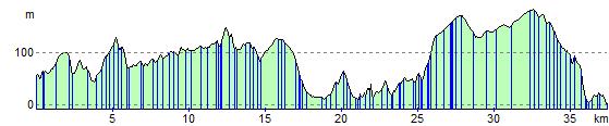
Fishguard to Cardigan
24.9 miles (40 km)
![]()
![]() Follow National Cycle routes 47 and 82 from Fishguard to Cardigan through the beautiful Pembrokeshire Coast National Park.
Follow National Cycle routes 47 and 82 from Fishguard to Cardigan through the beautiful Pembrokeshire Coast National Park.
You start in Fishguard and follow the River Gwaun and country roads to Newport, passing the Mynydd Carningli and some stunning scenery as you go. The route continues to Nevern where you cross the River Nevern and then head north to St Dogmaels via the fascinating Castell Henllys Iron Age Fort. At St Dogmaels you join the River Teifi following it to the finish point at Cardigan.
Fishguard to Cardigan Ordnance Survey Map  - view and print off detailed OS map
Fishguard to Cardigan Open Street Map  - view and print off detailed map
Fishguard to Cardigan OS Map  - Mobile GPS OS Map with Location tracking
Fishguard to Cardigan Open Street Map  - Mobile GPS Map with Location tracking
Cycle Routes and Walking Routes Nearby
Elevation Profile