Grantham to Newark-On-Trent
24.9 miles (40 km)
![]()
![]() This route follows National Cycle routes 15 and 64 through Lincolnshire, Leicestershire and Nottinghamshire. You start by the tourist information centre in Grantham and soon join the towpath of the Grantham Canal which takes you as far as Muston. From here you follow quiet roads to Bottesford. The route continues through the countryside on country lanes, joining National Cycle Route 64 just after Orston. A couple of miles later at Cotham you begin a short stretch on a dismantled railway line which takes you all the way to the finish point at Newark-On-Trent rail.
This route follows National Cycle routes 15 and 64 through Lincolnshire, Leicestershire and Nottinghamshire. You start by the tourist information centre in Grantham and soon join the towpath of the Grantham Canal which takes you as far as Muston. From here you follow quiet roads to Bottesford. The route continues through the countryside on country lanes, joining National Cycle Route 64 just after Orston. A couple of miles later at Cotham you begin a short stretch on a dismantled railway line which takes you all the way to the finish point at Newark-On-Trent rail.
Please see the Newark to Cotham Cycle Route for more details on this final section of the route.
Grantham to Newark-On-Trent Ordnance Survey Map  - view and print off detailed OS map
Grantham to Newark-On-Trent Open Street Map  - view and print off detailed map
Grantham to Newark-On-Trent OS Map  - Mobile GPS OS Map with Location tracking
Grantham to Newark-On-Trent Open Street Map  - Mobile GPS Map with Location tracking
Cycle Routes and Walking Routes Nearby
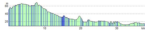
Elevation Profile