Greenwich to Cheshunt
![]()
![]() Follow National Cycle Route 1 on this pleasant ride or walk through north London into Hertfordshire. You start by the Thames at the Cutty Sark in Greenwich and crosses to the Isle of Dogs via the Greenwich tunnel. This section gives splendid views of the River Thames and Canary Wharf.
Follow National Cycle Route 1 on this pleasant ride or walk through north London into Hertfordshire. You start by the Thames at the Cutty Sark in Greenwich and crosses to the Isle of Dogs via the Greenwich tunnel. This section gives splendid views of the River Thames and Canary Wharf.
Shortly after leaving the Thames behind you will come onto the Lee Valley path which will take you along the Regent's Canal and through Tower Hamlets and Victoria Park. You then join the River Lee near Lea Bridge for some more waterside riding. The off road path then takes you past various Reservoirs until you reach the lovely Lee Valley Park - London's largest open space. After going through the park you will soon pass close to Waltham Abbey before you arrive at the finish point at Cheshunt station next to Cheshunt lake.
Greenwich to Cheshunt Ordnance Survey Map  - view and print off detailed OS map
Greenwich to Cheshunt Open Street Map  - view and print off detailed map
Greenwich to Cheshunt OS Map  - Mobile GPS OS Map with Location tracking
Greenwich to Cheshunt Open Street Map  - Mobile GPS Map with Location tracking
Cycle Routes and Walking Routes Nearby
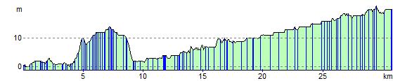
Elevation Profile