Hertford to Harpenden
16.2 miles (26 km)
![]()
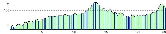
![]() This route starts in Hertford by the tourist information centre and heads west to Welwyn Garden City along National Cycle Route 61. This section is almost all off road following the Lee Valley Walk through some lovely countryside before passing through the attractive Welwyn Garden City. From there you will join National Cycle Route 57 on the Ayot Greenway path which takes you along the River Lee to Harpenden finishing at the train station.
This route starts in Hertford by the tourist information centre and heads west to Welwyn Garden City along National Cycle Route 61. This section is almost all off road following the Lee Valley Walk through some lovely countryside before passing through the attractive Welwyn Garden City. From there you will join National Cycle Route 57 on the Ayot Greenway path which takes you along the River Lee to Harpenden finishing at the train station.
Hertford to Harpenden Ordnance Survey Map  - view and print off detailed OS map
Hertford to Harpenden Open Street Map  - view and print off detailed map
*New* - Walks and Cycle Routes Near Me Map - Waymarked Routes and Mountain Bike Trails>>
Hertford to Harpenden OS Map  - Mobile GPS OS Map with Location tracking
Hertford to Harpenden Open Street Map  - Mobile GPS Map with Location tracking
Further Information and Other Local Ideas
In Harpenden you can pick up the epic Chilterns Cycleway. The signed circular trail runs for about 170 miles through the Chilterns AONB on quiet country lanes, visiting a series of delightful villages.
Cycle Routes and Walking Routes Nearby
Elevation Profile