Huddersfield to Leeds
34.8 miles (56 km)
![]()
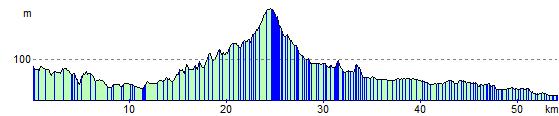
![]() This ride follows National Cycle Route 66 through Yorkshire. You start following the Huddersfield Canal and the River Calder to Dewsbury. You then turn north towards Bradford, passing through Cleckheaton Golf Course and Bowling Park on traffic free paths. From Bradford you continue to Shipley where you join the Leeds and Liverpool Canal which takes you into Leeds. A lot of this route is traffic free, fairly flat and along waterside paths making for a pleasant ride.
This ride follows National Cycle Route 66 through Yorkshire. You start following the Huddersfield Canal and the River Calder to Dewsbury. You then turn north towards Bradford, passing through Cleckheaton Golf Course and Bowling Park on traffic free paths. From Bradford you continue to Shipley where you join the Leeds and Liverpool Canal which takes you into Leeds. A lot of this route is traffic free, fairly flat and along waterside paths making for a pleasant ride.
Huddersfield to Leeds Ordnance Survey Map  - view and print off detailed OS map
Huddersfield to Leeds Open Street Map  - view and print off detailed map
Huddersfield to Leeds OS Map  - Mobile GPS OS Map with Location tracking
Huddersfield to Leeds Open Street Map  - Mobile GPS Map with Location tracking
Cycle Routes and Walking Routes Nearby
Elevation Profile