Hull to Driffield
34.2 miles (55 km)
![]()
![]() This is a lovely ride with plenty of traffic free sections following National Cycle Route 1 through Yorkshire. You start off at the tourist information centre in Hull and soon join an off road path taking you through Stoneferry and West Carr where you cross the River Hull. You then continue through Cottingham and Beverley parks on more off road paths before heading into Beverley. A series of quiet country roads then take you onto Driffield finishing with views of the River Hull and Driffield canal.
This is a lovely ride with plenty of traffic free sections following National Cycle Route 1 through Yorkshire. You start off at the tourist information centre in Hull and soon join an off road path taking you through Stoneferry and West Carr where you cross the River Hull. You then continue through Cottingham and Beverley parks on more off road paths before heading into Beverley. A series of quiet country roads then take you onto Driffield finishing with views of the River Hull and Driffield canal.
Hull to Driffield Ordnance Survey Map  - view and print off detailed OS map
Hull to Driffield Open Street Map  - view and print off detailed map
Hull to Driffield OS Map  - Mobile GPS OS Map with Location tracking
Hull to Driffield Open Street Map  - Mobile GPS Map with Location tracking
Cycle Routes and Walking Routes Nearby
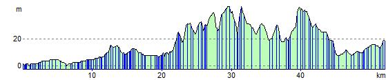
Elevation Profile