Macclesfield to Stoke-on-Trent
![]()
![]() This lovely ride follows National Cycle Route 55 through Cheshire to Staffordshire.
This lovely ride follows National Cycle Route 55 through Cheshire to Staffordshire.
You start in Macclesfield and head to Congleton on country roads with views of the Macclesfield Canal as you go. You will also pass the 15th century Gawsworth Hall and the pretty Redesmere on this section of the route.
The final section heads along the Biddulph Valley Way - a traffic free disused railway path that will take you near to the outskirts of Stoke. From here you will head into Stoke passing through Central Forest and Hanley parks before finishing at the train station.
Macclesfield to Stoke-on-Trent Ordnance Survey Map  - view and print off detailed OS map
Macclesfield to Stoke-on-Trent Open Street Map  - view and print off detailed map
Macclesfield to Stoke-on-Trent OS Map  - Mobile GPS OS Map with Location tracking
Macclesfield to Stoke-on-Trent Open Street Map  - Mobile GPS Map with Location tracking
Further Information and Other Local Ideas
Just to the east of Stoke there's some nice trails around Park Hall Country Park. The former quarry site is now notable as Stoke on Trent's only National Nature Reserve comprising woodland, heathland and ponds.
Cycle Routes and Walking Routes Nearby
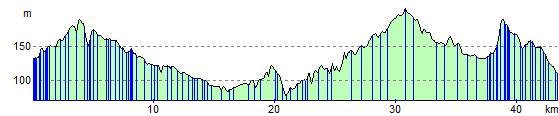
Elevation Profile