Manchester to Stockport
13.7 miles (22 km)
![]()
![]() Follow National Cycle routes 6 and 62 through Manchester on this pleasant ride. You start by Manchester Oxford Road station heading south through Chorlton to the River Mersey. Here you join a lovely traffic free section along the Trans Pennine Trail which takes you to Stockport, finishing at the train station.
Follow National Cycle routes 6 and 62 through Manchester on this pleasant ride. You start by Manchester Oxford Road station heading south through Chorlton to the River Mersey. Here you join a lovely traffic free section along the Trans Pennine Trail which takes you to Stockport, finishing at the train station.
Manchester to Stockport Ordnance Survey Map  - view and print off detailed OS map
Manchester to Stockport Open Street Map  - view and print off detailed map
Manchester to Stockport OS Map  - Mobile GPS OS Map with Location tracking
Manchester to Stockport Open Street Map  - Mobile GPS Map with Location tracking
Cycle Routes and Walking Routes Nearby
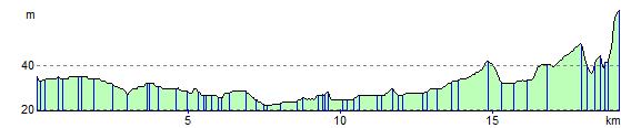
Elevation Profile