March to Wisbech
12.4 miles (20 km)
![]()
![]() This easy route follows National Cycle Route 63 through Cambridgeshire. The route starts by the railway station in March and heads north along a mixture of off road paths and country roads finishing by the tourist information centre in Wisbech.
Highlights include views of the Twenty Foot River and some lovely rural views.
This easy route follows National Cycle Route 63 through Cambridgeshire. The route starts by the railway station in March and heads north along a mixture of off road paths and country roads finishing by the tourist information centre in Wisbech.
Highlights include views of the Twenty Foot River and some lovely rural views.
March to Wisbech Ordnance Survey Map  - view and print off detailed OS map
March to Wisbech Open Street Map  - view and print off detailed map
March to Wisbech OS Map  - Mobile GPS OS Map with Location tracking
March to Wisbech Open Street Map  - Mobile GPS Map with Location tracking
Cycle Routes and Walking Routes Nearby
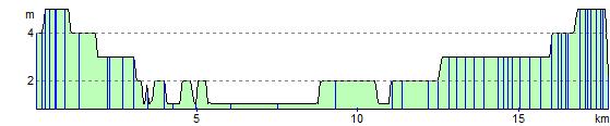
Elevation Profile