Marlborough to Swindon
26.1 miles (42 km)
![]()
![]() Follow regional routes 20 and 26 from Marlborough to Swindon through some lovely Wiltshire countryside.
Follow regional routes 20 and 26 from Marlborough to Swindon through some lovely Wiltshire countryside.
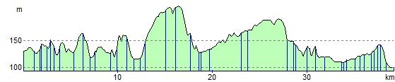
The route starts near the Marlborough White Horse and heads east along the River Kennet to Ramsbury via Stitchcombe and Axford. You then head north to Wanborough and then onto Liddington where you'll pass the noteworthy Liddington Hill. A final pleasant strech around the attractive Coate Water Country Park then takes you to the outskirts of Swindon.
Marlborough to Swindon Ordnance Survey Map  - view and print off detailed OS map
Marlborough to Swindon Open Street Map  - view and print off detailed map
Marlborough to Swindon OS Map  - Mobile GPS OS Map with Location tracking
Marlborough to Swindon Open Street Map  - Mobile GPS Map with Location tracking
Elevation Profile