Newcastle to Bellingham
55.9 miles (90 km)
![]()
![]() This long route takes you from Tyne and Wear into Northumberland along National Cycle routes 72 and 10.
You start by Newcastle Upon Tyne rail station and head along National Cycle route 72 and the River Tyne to East Howdon. A long off road stretch along a dismantled railway line followed by some country roads takes you to Ponteland along National Cycle Route 10 and the Reivers Route. The ride continues on road through Northumberland with some lovely scenery including views of the River North Tyne and Colt Crag Reservoir. You finish at the tourist information centre at Bellingham - a popular stopping place for walkers and cyclists visiting the Pennine Way Trail.
This long route takes you from Tyne and Wear into Northumberland along National Cycle routes 72 and 10.
You start by Newcastle Upon Tyne rail station and head along National Cycle route 72 and the River Tyne to East Howdon. A long off road stretch along a dismantled railway line followed by some country roads takes you to Ponteland along National Cycle Route 10 and the Reivers Route. The ride continues on road through Northumberland with some lovely scenery including views of the River North Tyne and Colt Crag Reservoir. You finish at the tourist information centre at Bellingham - a popular stopping place for walkers and cyclists visiting the Pennine Way Trail.
Newcastle to Bellingham Ordnance Survey Map  - view and print off detailed OS map
Newcastle to Bellingham Open Street Map  - view and print off detailed map
Newcastle to Bellingham OS Map  - Mobile GPS OS Map with Location tracking
Newcastle to Bellingham Open Street Map  - Mobile GPS Map with Location tracking
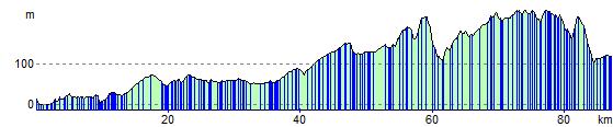
Cycle Routes and Walking Routes Nearby
Elevation Profile