Oxford to Princes Risborough
24 miles (38 km)

 Follow National Cycle Route 57 on this lovely route through the Oxfordshire countryside. The route starts near the tourist information centre in Oxford and heads east to Thame on minor roads. You then join the Phoenix Trail - a lovely off road path on a dismantled railway line which takes you to the finish point at Princes Risborough rail.
This route also has splendid views of the Chiltern Hills throughout.
Oxford to Princes Risborough Ordnance Survey Map  - view and print off detailed OS map
Oxford to Princes Risborough Open Street Map  - view and print off detailed map
Oxford to Princes Risborough OS Map  - Mobile GPS OS Map with Location tracking
Oxford to Princes Risborough Open Street Map  - Mobile GPS Map with Location tracking
Further Information and Other Local Ideas
In Princes Risborough you can pick up the epic Chilterns Cycleway. The signed circular trail runs for about 170 miles through the Chilterns AONB on quiet country lanes, visiting a series of delightful villages.
Cycle Routes and Walking Routes Nearby
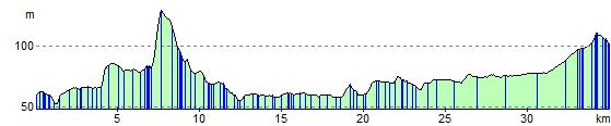
Elevation Profile