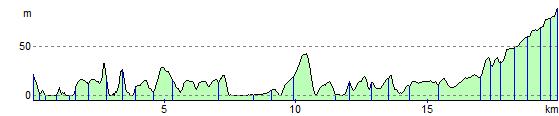
Padstow to Bodmin
13.7 miles (22 km)
![]()
![]() Follow the Camel Trail from Padstow to Bodmin via Wadebridge.
Follow the Camel Trail from Padstow to Bodmin via Wadebridge.
The trail follows a disused railway line and the River Camel through attractive moorland and woodland and is ideal for families being flat and off road.
Padstow to Bodmin Ordnance Survey Map  - view and print off detailed OS map
Padstow to Bodmin Open Street Map  - view and print off detailed map
Padstow to Bodmin OS Map  - Mobile GPS OS Map with Location tracking
Padstow to Bodmin Open Street Map  - Mobile GPS Map with Location tracking
Further Information and Other Local Ideas
Near Wadebridge you could pay a trip to Grogley Woods. The woods are a popular place for mountain bikers with several black graded trails to try. The site is located just to the south of the town and includes some fine downhill lines and jumps.
Elevation Profile