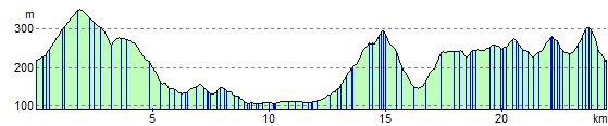
Pendle Hill Cycle
15.5 miles (25 km)
![]()
![]() This is a short but challenging circular route that takes you around the fringes of the towering Pendle Hill which stands 557 metres high.
This is a short but challenging circular route that takes you around the fringes of the towering Pendle Hill which stands 557 metres high.
The routes starts and finishes at Barley and follows part of National Cycle route 91 through some pretty villages and lovely countryside. Click here for a leaflet containing this and other Lancashire rides.
If you'd like to walk to the summit and enjoy great views over the Forest of Bowland then see the Pendle Hill Walk.
Pendle Hill Ordnance Survey Map  - view and print off detailed OS map
Pendle Hill Open Street Map  - view and print off detailed map
Pendle Hill OS Map  - Mobile GPS OS Map with Location tracking
Pendle Hill Open Street Map  - Mobile GPS Map with Location tracking
Elevation Profile