Penrith to Carlisle
24.9 miles (40 km)
![]()
![]() Travel along National Cycle Route 7 on this attractive ride through Cumbria. You start in Penrith heading into the Cumbrian countryside towards Dalston on a series of quiet roads. You then join the lovely Cumbria way taking you along the River Caldew which leads you into Carlisle. Highlights on the route include the castles at Penrith, Dalston and Carlisle (below)
Travel along National Cycle Route 7 on this attractive ride through Cumbria. You start in Penrith heading into the Cumbrian countryside towards Dalston on a series of quiet roads. You then join the lovely Cumbria way taking you along the River Caldew which leads you into Carlisle. Highlights on the route include the castles at Penrith, Dalston and Carlisle (below)
Penrith to Carlisle Ordnance Survey Map  - view and print off detailed OS map
Penrith to Carlisle Open Street Map  - view and print off detailed map
Penrith to Carlisle OS Map  - Mobile GPS OS Map with Location tracking
Penrith to Carlisle Open Street Map  - Mobile GPS Map with Location tracking
Further Information and Other Local Ideas
The Reivers Route passes through Carlisle. The popular coast to coast ride crosses the country from Whitehaven to Tynemouth. The signed trail runs mostly along National Cycle Route 10.
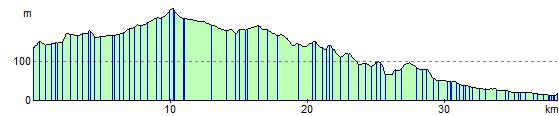
Elevation Profile