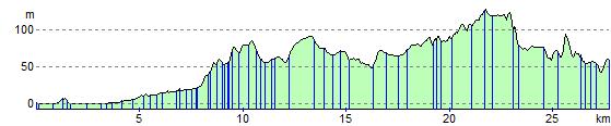
Perth to Dunkeld
17.4 miles (28 km)
![]()
![]() This lovely route follows the River Tay and National Cycle Route 77 from Perth to Dunkeld.
This lovely route follows the River Tay and National Cycle Route 77 from Perth to Dunkeld.
The ride is easily accessible with train stations at either end.
Perth to Dunkeld Ordnance Survey Map  - view and print off detailed OS map
Perth to Dunkeld Open Street Map  - view and print off detailed map
Perth to Dunkeld OS Map  - Mobile GPS OS Map with Location tracking
Perth to Dunkeld Open Street Map  - Mobile GPS Map with Location tracking
Cycle Routes and Walking Routes Nearby
Elevation Profile