Peterborough to March
19.9 miles (32 km)
![]()
![]() Follow National Cycle Route 63 from Peterborough to March on this easy route. The start of the route follows the River Nene out of Peterborough to Whittlesey before a series of off road tracks and quiet country lanes take you into March finishing at the train station.
Follow National Cycle Route 63 from Peterborough to March on this easy route. The start of the route follows the River Nene out of Peterborough to Whittlesey before a series of off road tracks and quiet country lanes take you into March finishing at the train station.
The Peterborough Green Wheel is a great way of further exploring the city on a signed route. The fairly easy 20 mile circular trail visits Ferry Meadows Country Park, the River Nene Way and the villages of Marholm and Etton.
Peterborough to March Ordnance Survey Map  - view and print off detailed OS map
Peterborough to March Open Street Map  - view and print off detailed map
Peterborough to March OS Map  - Mobile GPS OS Map with Location tracking
Peterborough to March Open Street Map  - Mobile GPS Map with Location tracking
Cycle Routes and Walking Routes Nearby
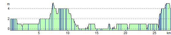
Elevation Profile