Peterborough to Stamford
16.8 miles (27 km)
![]()
![]() Follow National Cycle Route 63 through Cambridgeshire and onto Lincolnshire. You start by the railway station in Peterborough and soon join a lovely off road section that runs along the River Nene and through Ferry Meadows Country Park. You then continue on road through Castor and Ailsworth before passing the lovely Castor Hanglands. The ride then progresses onto Stamford via Barnack, crossing the River Welland before finishing by the tourist information centre in Stamford.
Follow National Cycle Route 63 through Cambridgeshire and onto Lincolnshire. You start by the railway station in Peterborough and soon join a lovely off road section that runs along the River Nene and through Ferry Meadows Country Park. You then continue on road through Castor and Ailsworth before passing the lovely Castor Hanglands. The ride then progresses onto Stamford via Barnack, crossing the River Welland before finishing by the tourist information centre in Stamford.
Peterborough to Stamford Ordnance Survey Map  - view and print off detailed OS map
Peterborough to Stamford Open Street Map  - view and print off detailed map
Peterborough to Stamford OS Map  - Mobile GPS OS Map with Location tracking
Peterborough to Stamford Open Street Map  - Mobile GPS Map with Location tracking
Further Information and Other Local Ideas
The Peterborough Green Wheel Cycle Route is a great way of further exploring the city on a signed route. The fairly easy 20 mile circular trail visits Ferry Meadows, the River Nene Way and the villages of Marholm and Etton.
Cycle Routes and Walking Routes Nearby
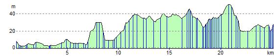
Elevation Profile