Pitlochry to Aberfeldy
![]()
![]() Follow the Rivers Tummel and Tay along National Cycle Route 7 on this lovely short route through the Highlands.
Follow the Rivers Tummel and Tay along National Cycle Route 7 on this lovely short route through the Highlands.
The ride starts in Pitlochry and first follows the River Tummel to Logierait. Here you join the River Tay, following it west towards Grandtully and then onto Aberfeldy on quiet roads.
The ride finishes by crossing the Tay on the impressive Wade's bridge in Aberfeldy, and coming to a stop outside the tourist information centre.
Pitlochry to Aberfeldy Ordnance Survey Map  - view and print off detailed OS map
Pitlochry to Aberfeldy Open Street Map  - view and print off detailed map
Pitlochry to Aberfeldy OS Map  - Mobile GPS OS Map with Location tracking
Pitlochry to Aberfeldy Open Street Map  - Mobile GPS Map with Location tracking
Further Information and Other Local Ideas
In Pitlochry you can link up with National Cycle Route 77 which runs to Perth, Dunkeld and Dundee along a route known as the 'Salmon Run'.
Near Kenmore there's the delightful Falls Of Acharn to visit. The scenic spot includes a Victorian 'Hermit's Cave' and some great views back to Ben Lawers from Acharn village.
Cycle Routes and Walking Routes Nearby
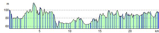
Elevation Profile