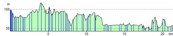
Pitlochry to Dunkeld
14.3 miles (23 km)
![]()
![]() Follow the Rivers Tummel and Tay along National Cycle Route 7 on this lovely short route through the Highlands.
Follow the Rivers Tummel and Tay along National Cycle Route 7 on this lovely short route through the Highlands.
The ride starts in Pitlochry and follows the River Tummel to Logierait. From here you join the River Tay, following it through the atmospheric Tay Forest Park before joining a traffic free riverside path which takes you into Dunkeld.
Pitlochry to Dunkeld Ordnance Survey Map  - view and print off detailed OS map
Pitlochry to Dunkeld Open Street Map  - view and print off detailed map
Pitlochry to Dunkeld OS Map  - Mobile GPS OS Map with Location tracking
Pitlochry to Dunkeld Open Street Map  - Mobile GPS Map with Location tracking
Further Information and Other Local Ideas
In Dunkeld you can link up with National Cycle Route 77 which runs to Perth and Dundee along a route known as the 'Salmon Run'.
Cycle Routes and Walking Routes Nearby
Elevation Profile