Preston to Lancaster
34.2 miles (55 km)
![]()
![]() Follow National Cycle Route 6 from Preston to Lancaster and take in the Forest of Bowland and the Lancaster canal along the way of this cruisy and attractive route.
Follow National Cycle Route 6 from Preston to Lancaster and take in the Forest of Bowland and the Lancaster canal along the way of this cruisy and attractive route.
You start off near Preston train station and head through the town to Moor Park where you'll pass Deepdale - home of Preston North End FC. The ride continues north into the countryside towards Garstang and Scorton where there are views of the River Wyre and Cleveley Mere. After passing through Galgate and crossing the Lancaster Canal you will join the River Lune for a lovely traffic free waterside stretch. This section passes the picturesque Conder Green and Glasson Dock. Quiet roads and another waterside run along the Lancaster Canal take you into Lancaster.
Preston to Lancaster Ordnance Survey Map  - view and print off detailed OS map
Preston to Lancaster Open Street Map  - view and print off detailed map
Preston to Lancaster OS Map  - Mobile GPS OS Map with Location tracking
Preston to Lancaster Open Street Map  - Mobile GPS Map with Location tracking
Cycle Routes and Walking Routes Nearby
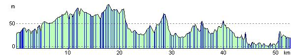
Elevation Profile