Shrewsbury to Telford
![]()
![]() Follow National Cycle routes 81, 45 and 55 through Shropshire on this pleasant ride. The ride starts near the train station in Shrewsbury and soon joins the Shropshire Way which takes you along the River Severn and National Cycle Route 81 to Upton Magna. The route then follows National Cycle Route 45 along country roads with regular views of the river and a short stretch through Attingham Park. This is a good place to stop for a break and see the the mansion and deer park.
Follow National Cycle routes 81, 45 and 55 through Shropshire on this pleasant ride. The ride starts near the train station in Shrewsbury and soon joins the Shropshire Way which takes you along the River Severn and National Cycle Route 81 to Upton Magna. The route then follows National Cycle Route 45 along country roads with regular views of the river and a short stretch through Attingham Park. This is a good place to stop for a break and see the the mansion and deer park.
There are also splendid views of The Wrekin - part of the Shropshire Hills AONB. Shortly after passing The Wrekin you'll join the Severn Way taking you along the river into Ironbridge. Here you join National Cycle route 55 to Coalport and then Telford following off road paths.
Shrewsbury to Telford Ordnance Survey Map  - view and print off detailed OS map
Shrewsbury to Telford Open Street Map  - view and print off detailed map
Shrewsbury to Telford OS Map  - Mobile GPS OS Map with Location tracking
Shrewsbury to Telford Open Street Map  - Mobile GPS Map with Location tracking
Cycle Routes and Walking Routes Nearby
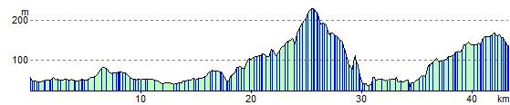
Elevation Profile