Slaidburn to Whalley
18.6 miles (30 km)
![]()
![]() This rural route along the Lancashire Cycleway gives splendid views of the Forest of Bowland and in particular Longridge Fell as you travel from
Slaidburn to Whalley.
This rural route along the Lancashire Cycleway gives splendid views of the Forest of Bowland and in particular Longridge Fell as you travel from
Slaidburn to Whalley.
Other route highlights include views of the River Hodder and River Ribble and of Pendle Hill with its fascinating history.
The ride also passes through several pretty villages including Waddington and Great Mitton.
In Whalley you can visit the interesting ruins of Whalley Abbey next to the River Calder.
Slaidburn to Whalley Ordnance Survey Map  - view and print off detailed OS map
Slaidburn to Whalley Open Street Map  - view and print off detailed map
Slaidburn to Whalley OS Map  - Mobile GPS OS Map with Location tracking
Slaidburn to Whalley Open Street Map  - Mobile GPS Map with Location tracking
Cycle Routes and Walking Routes Nearby
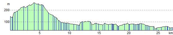
Elevation Profile