St Austell to Bodmin
![]()
![]() Follow National Cycle Route 3 on this short route which passes through some lovely countryside. The main highlight on the route though is the splendid Eden Project which is near the beginning of the route. Here you can see giant greenhouses with fantastic plantlife and beautiful gardens and exhibits.
Also on the route is the lovely Breney Common Nature Reserve and just to the east the Helman Tor Geological Site. Finally be sure to visit Lanhydrock - a magnificent country house owned by the National Trust and situated just before the end of the route at Bodmin.
Follow National Cycle Route 3 on this short route which passes through some lovely countryside. The main highlight on the route though is the splendid Eden Project which is near the beginning of the route. Here you can see giant greenhouses with fantastic plantlife and beautiful gardens and exhibits.
Also on the route is the lovely Breney Common Nature Reserve and just to the east the Helman Tor Geological Site. Finally be sure to visit Lanhydrock - a magnificent country house owned by the National Trust and situated just before the end of the route at Bodmin.
St Austell to Bodmin Ordnance Survey Map  - view and print off detailed OS map
St Austell to Bodmin Open Street Map  - view and print off detailed map
St Austell to Bodmin OS Map  - Mobile GPS OS Map with Location tracking
St Austell to Bodmin Open Street Map  - Mobile GPS Map with Location tracking
Further Information and Other Local Ideas
The route passes close to the popular Luxulyan Valley, a designated World Heritage Site. The valley is one of the highlights of the area with nice trails along the River Par, a series of historical industrial remains and the impressive Treffry Viaduct to see.
Cycle Routes and Walking Routes Nearby
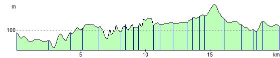
Elevation Profile